
Service hours are currently 8:00 a.m. to 4:00 p.m., Monday thru Friday.
While permit applications may be dropped off during these hours, review and issuance will generally take 1 to 3 days rather than while you wait. Please consider submitting your application electronically by e-mail to plandev@danecounty.gov
Appointments are not required but are appreciated.
We accept cash, check, or can provide you an invoice through Square for payment by credit or debit.
Dane County Zoning will investigate potential violations and complaints that are submitted in writing to our department. Please send complaints via e-mail or mail to:
Dane County Zoning
210 Martin Luther King Jr. Blvd Rm 116
Madison WI 53703
The County Surveyor's Office does not provide field services. You can have your property surveyed by hiring a private sector licensed land surveyor. If a survey of your property has previously been recorded you can retrieve a copy of the survey from the Surveyor's office.
Dane County Land and Water Resources, 5201 Fen Oak Dr Ste 208, Madison, WI 53718, 608-224-3730
https://lwrd.danecounty.gov/what-we-do/erosion-control
Driveway permits may be obtained at the local municipality. Here is a directory with contact information: https://clerk.danecounty.gov/documents/pdf/directory.pdf
Building permits may be obtained at the local municipality. Here is a directory with contact information: https://clerk.danecounty.gov/documents/pdf/directory.pdf
You will have to contact Environmental Health for more information on your sewer or septic system. Their phone number is 608-242-6515 and their address is 2300 S. Park St.
Environmental Health (Madison Dane County), 2300 S Park St, Madison, WI 53713, 608-266-4821
What can I expect to pay for printing a survey or any other fees?? See the 2022 Office Fees sheet County Surveyor's Office | Dane County Planning & Development
The current issue of the Dane County Plat Book is available for purchase. Previous versions might be available for purchase or viewing. Email plandev@danecounty.gov or call 608-266-4253 for more details.
If you still have questions send us an email at plandev@danecounty.gov or give us a call at 608-266-4266.
For zoning questions about your property you have two options:
Instructions on how to use AccessDane to find the zoning of your property can be found here.
No. Dane County Zoning only has jurisdiction for the rural areas of the County. If you are within a City or Village you should contact the City or Village directly for all permitting requirements.
Yes, you can email your application to zoning@danecounty.gov but do keep in mind that if you email it in and are missing any additional information, it could delay the process.
Yes. Please mail a copy of your application and associated plans to:
Dane County Zoning
210 Martin Luther King Jr. Blvd Rm 116
Madison WI 53703
Fees are payable to Dane County Zoning
If you still have questions send us an email at plandev@danecounty.gov or give us a call at 608-266-4266.
Each Town in Dane County has it's own set of development rules. Contact the Dane County planner that is familiar with the Town you live in and we can walk you through the process. Most likely you will have to go through the Density Study process to get a handle how many homes can be built on your property.
If you still have questions send us an email at plandev@danecounty.gov or give us a call at 608-266-4266.
Dane County Planning and Development maintains property information for all tax parcels in Dane County except the City of Madison. Questions about your property may be directed to their Assessor’s Office by e-mail at assessor@cityofmadison.com or by phone (608) 266-4531
Tax bills are generated for a property as it existed as of January 1st of that tax year.
If the property is split and new tax parcels are created and sold during that tax year, those new tax parcels will not be assessed or taxed until the following year. Unless our office is notified to update the parent parcel (the current year tax parcel), the bills will be sent to the owner of the parcel prior to the split. In situations like this, property owners may request a split tax bill after the bills have been generated. Contact your local treasurer and request a split of the bill. Local treasurers will then work with the local assessor to determine the appropriate amount is prorated.
When new lots, or parcels are created during the year, new parcel numbers are assigned. However, assessments are based on how the property existed on January 1 of the given year. If a parcel is split during the year, the tax bill will go out as a whole to the person who owned it when it was split. The new parcels will not be assessed or taxed until the following year. If you would like the tax bill split, contact the treasurer for your municipality. Under certain circumstances they may split the tax bill for you.
The assessment acres on Access Dane are the responsibility of the assessor contracted for that municipality. They use a variety of methods to determine the acreage including recorded land surveys, GIS tax parcel size and aerial photograph interpretation. If you feel the acreage is not correct or should not have changed contact the assessor for more details.
Our office is required to maintain the values established by the assessor for your municipality. If you do not agree with your values, you should first contact your assessor to discuss it. A good source of information is the state Department of Revenue website which contains information on property owners' rights and information about the assessment process.
Below are some helpful guides to provide a strong foundation for people to understand how assessments are made.
To review the best evidence of property value, see the Wisconsin Department Revenue’s Guide for Property Owners.
Helpful links in understanding more about the assessment of your property include the Agricultural Assessment Guide for WI Property Owners and the Wisconsin Property Assessment Manual.
You may use this form for an Objection to Real Property Assessment and then submit it to your municipal clerk.
Our office is required to list the owners of real estate according to the recorded documents in the Register of Deeds office. If there was no type of documentation to change the ownership in the property (quit claim deed, divorce judgment, etc.) we do not have any way of changing the names. In this case, you may wish to check with the attorney handling the divorce about transferring the property.
It depends on how the title to the property was held. If the property was held in joint tenancy or survivorship marital property, you can file a Termination of Decedent’s Interest form with the Register of Deeds office. This form is available at the Register of Deeds office and the staff can provide you with instructions on filling out the form. If the property was not titled this way, you may wish to contact an attorney to help transfer the property, especially if the property needs to go through probate.
If you haven’t recorded any document to transfer the title to your property since your marriage, the name reflected on the tax bill and assessment notice will be the same as listed on the conveyance where you took title. To change the ownership, you may contact an attorney to prepare the documents. Or, if you feel comfortable doing it yourself, you may download the deed forms from the link provided on the Register of Deeds website Click on the link under Real Estate labeled Deeds.
The Dane County Surveyor’s office has copies of plats and property surveys. To contact that office, email the address to plandev@danecounty.gov or call 266-4253.
Dane County Zoning has information on zoning for properties in rural Dane County. You may also try checking the Access Dane website. If the property is located within an incorporated city or village, you will need to contact the appropriate department in that municipality.
For first installment amounts, you should check with the treasurer for your municipality. After that, check with the Dane County Treasurer’s office at 266-4151.
If you would like the properties to be assessed together, you may contact the assessor for your municipality. If the properties are assessed together, you will get one assessment notice and one tax bill, but the properties will continue to be listed individually in the assessment roll. If you want the real estate parcels combined to create one assessment parcel, please contact our office so we may review the parcels. Sometimes, due to taxing district boundaries, such as school or tif districts, we are not able to combine parcels for taxpayers.
Yes we can. Use the Custom Map link here https://lio.danecounty.gov/services/custom-maps to request just such a map. Common requests might include: aerial photograph (current and historical), elevation and land use. You can also use DCiMap to create a PDF snapshot or export a map, check out the help section.
Yes you can. First check the Open Data Portal at the Land Information Office for data that you can download and use with select mapping software https://gis-countyofdane.opendata.arcgis.com/ . If you desire something custom (for example tax parcels with an improvement value above $100,000 in a specific census tract that are within 2 miles of a highway) you can request that tabular data through the Custom Map link here https://lio.danecounty.gov/services/custom-maps .
If you still have questions send us an email at plandev@danecounty.gov or give us a call at 608-266-4266.
The Zoning Division of the Dane County Department of Planning and Development should be your first stop if you are thinking of doing work near the shore. County zoning staff can review your plans and let you know what permits, if any, you will need. If necessary, zoning staff may refer you to the Land and Water Resources Division for additional permits or reviews.
State statute defines shorelands as areas within 1,000 feet of a navigable lake or pond and within 300 feet of a navigable river or stream.
In their natural state, shorelands provide critical environmental functions, including water filtration, soil stabilization and habitat for a wide variety of fish and wildlife. The Wisconsin Department of Natural Resources estimates that 94% of all aquatic life spends at least part of its life cycle within 30 feet of the shore. By replacing natural shore cover with pavement, buildings and turf grass, poorly designed development can impair or disrupt these functions, creating severe environmental impacts. Under Section 59.692 of the Wisconsin Statutes, every county in the state must adopt ordinances that regulate development in shorelands, in order to protect water quality, natural scenic beauty and fish and wildlife habitat. County ordinances must meet or exceed minimum standards established in NR 115, Wisconsin Administrative Code.
 Navigable waters are defined in the Public Trust Doctrine and state statute. Generally, they include all natural lakes, ponds, rivers and streams (including intermittent streams). Artificial drainages or stormwater conveyances that were not previously natural waterways are generally not considered navigable. Waters shown in USGS Quadrangle maps, Dane County floodplain maps, or the County GIS system are presumed to be navigable. The Dane County Zoning Administrator or the Wisconsin Department of Natural Resources can determine whether or not a particular waterway is navigable under state law.
The ordinary high water mark (or OHWM) represents the highest point on the shore where the water can be expected to reach each year, such as in spring flood. During late summer, or in a drought, the actual water level might be lower than the OHWM. On the other hand, during a flood, the actual water level might be considerably higher than the OHWM. The OHWM serves as the dividing line between Wisconsin DNR regulatory authority and county shoreland zoning, and is also the measurement point for building setbacks and the vegetative buffer zone. If there is some question about where the OHWM is located, the County Zoning Administrator or the Wisconsin DNR can set the ordinary highwater mark based on field conditions.
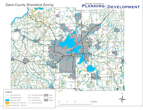
The Dane County Shoreland Zoning Ordinance applies only to properties in unincorporated towns. If you are in an incorporated city or village, check with your local zoning agency 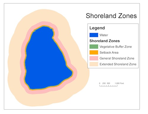 to determine what regulations apply.
In unincorporated areas, the county ordinance creates a series of rings or buffers around each waterway. Depending on how far your project is from the water, different regulations apply.
The closer to the water, the more protective the regulations become.
a. New lots must meet minimum lot size and width standards.
a. New lots must meet minimum lot size and width standards.
b. Shoreland erosion control permits are required before disturbing any land. Simplified applications are available for small projects.
c. Shoreland zoning permits are required before:
i. Building any new permanent or temporary structure.
ii. Adding on to, or expanding (vertically or horizontally) any existing structure.
iii. Making changes to any impervious surfaces (including buildings, pavement, patios, walkways, etc.). Impervious surfaces cannot exceed the current percentage of the lot, or 15%, whichever is greater.
d. Shoreland mitigation permits are required before covering between 15% and 30% of any lot with an impervious surface.
a. Shoreland mitigation permits are required before:
i. Building any new permanent or temporary structure.
ii. Adding on to, or expanding (vertically or horizontally) any existing structure.
a. No structures are permitted, except for boathouses, piers and walkways.
b. No permit is required for "routine maintenance" (including lawn mowing) of existing vegetation, as long as you do not disturb any ground, and do not remove any layer of existing vegetation. For example, selective pruning of trees would qualify as "routine maintenance," but removing whole trees would not.
c. Shoreland zoning permits are required before:
i. Removing existing vegetation to create a viewing and access corridor to get to the water.
ii. Building a stairway, walkway or railings, when needed to access the shore.
d. Shoreland mitigation permits are required for:
i. Removing any vegetation, except for viewing and access corridors and routine maintenance.
ii. Building a new, or adding onto an existing, boathouse.
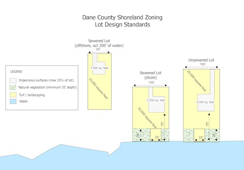 New lots in the shoreland zone must meet minimum lot widths and area standards, depending on where they are in relation to the shore and whether or not they are on public sewer. Buildings, with the exception of permitted boathouses and walkways, should be a minimum of 75 feet from the ordinary high water mark. The first 35 feet from the shore, except for viewing and access corridors, should be left in a natural state. If your project meets the lot design standards, you will need shoreland zoning permits and (in most cases) shoreland erosion control permits, but you will not need a shoreland mitigation permit.
State law requires counties to adopt mitigation standards that are proportional to the impact of development on water quality, fish and wildlife habitat and natural scenic beauty. In Dane County, mitigation standards include two components:
A shoreland mitigation permit allows for a wider variety of development options than is possible with only a shoreland zoning permit.
Dane County ordinance and state and federal law prohibit most construction, ditching or fill within wetland boundaries. In addition, the Dane County shoreland zoning ordinance requires that all new structures be at least 75 feet from the boundary of any wetland 2 acres or larger. The maps of the Wisconsin Wetland Inventory give a good general idea of the location of wetlands across the state. However, maps are no substitute for a field delineation to determine precise wetland boundaries. Please note that if you are proposing a project that is located close to a mapped wetland boundary, you will need a wetland delineation and a location survey to make sure wetland setbacks are met.
Yes, as long as the lot:
Shoreland zoning permits , shoreland mitigation permits and shoreland erosion control permits will apply to any new construction. New construction will have to meet all floodplain regulations, setbacks, wetland buffers, impervious surface limits, vegetative buffer zone protections or appropriate mitigation standards. Variances are not required unless physical limitations of the lot make it impossible to meet either site design or mitigation standards.
The county shoreland zoning ordinance makes special provisions for legal, nonconforming buildings and structures that were built before the ordinance went into effect.
County shoreland permits are not required for any of the following:
Note that depending on the type of work being done, town building or driveway permits and county sanitary permits may still apply. Additionally if the structure is located in the regulatory floodplain these projects may require a floodplain development permit.
Shoreland zoning permits are required before:
Shoreland mitigation permits are required before:
Shoreland erosion control permits are required before disturbing any ground, whether or not the work is associated with a nonconforming building or structure.
In most cases, no, as long as your property complies with a recently-approved farm conservation plan. Contact the Dane County Land Conservation Division to see if your farm plan is up to date.
Most shoreland projects will either meet the basic lot design standards, or can meet performance standards with simple, relatively inexpensive, mitigation practices. In rare cases, unique circumstances, such as extremely small or oddly shaped lots, may make it impossible to meet ordinance standards and still have a "reasonable use" of the property. If you have exhausted your mitigation options, and your project cannot be redesigned to comply with the ordinance, you may be eligible for a variance from the Dane County Board of Adjustment.
If you still have questions send us an email at plandev@danecounty.gov or give us a call at 608-266-4266.
The Dane County Zoning Division is responsible for assigning rural addresses for properties located outside of cities and villages. Property addresses are essential for navigation and emergency services. It's important to note that rural addresses are not assigned to vacant land; they are exclusively tied to principal structures on a property.
For most property owners, obtaining a rural address is a streamlined process. When you apply for a zoning permit through Dane County Zoning for a new principal structure, the address is assigned as part of that permit issuance. No separate application or additional fee is required in these cases.
However, if your property is located within one of the six towns that have opted out of Dane County Zoning, you'll need to apply for an address assignment directly through Dane County Zoning. This is done by completing the Rural Address Application. The application can be e-mailed to Dane County Zoning; you may request a Square invoice to pay the fee with a credit card online or you may mail a check payable to Dane County Zoning.
Towns that have opted out of Dane County Zoning: Berry, Blue Mounds, Bristol, Springfield, Sun Prairie, and Westport.
Be sure to contact diggers hotline before installing your address placard post.
The sign shall be installed so that the numbers are perpendicular to the roadway and the post shall be located not more than 10 feet from the right of way of the road and not more than 10 feet from the driveway serving the building. The sign shall be installed to be not less than 3 ½ feet nor more than 4 ½ feet from ground level and shall not be concealed from view of the road.
Unfortunately requests for specific numbers cannot be fulfilled. Rural addresses are based on a grid system that coordinates with Dane County 911 automated dispatch. It's important the the number used for your property falls within the correct grid location. Other factors also contribute to the numbers assigned by staff to ensure the safe and effective delivery of emergency services.
First check AccessDane to verify your property address is associated with your parcel. If it is not listed contact our staff.
If your property address is correct in AccessDane, and the USPS reports that your address is not valid, contact Dane County Planning and Development for townships, or your city or village clerk, to have them provide confirmation of a valid address to the USPS Address Management Service.
If your property address is correct in AccessDane, and delivery drivers are having trouble finding your location you may need to report mapping errors to external services such as Google Maps or Microsoft Bing. This can usually be done by right clicking the area on the map and "reporting an error".
Please note it can take some time for an address to make its way into external databases after being assigned by the municipality.
Dane County is only responsible for assigning the street number and road name portion of the address. The post office and zip code is determined by USPS based on which post office will serve your property. The post office may or may not coincide with the municipality in which you reside. You may be able to determine which post office serves your property by looking at neighboring addresses on AccessDane. If the billing address matching the property address, you can see what post office is serving neighboring properties. The best way to confirm is to contact the USPS directly.
If you still have questions send us an email at plandev@danecounty.gov or give us a call at 608-266-4266.
