

Dan Frick, Dane County Surveyor
Phone: 608-266-4252
Fax: 608-267-1540
Email: Frick.daniel@danecounty.gov
Duties of the Office:
To maintain the records of the Dane County Surveyor's Office, including the Public Land Survey System (PLSS) information on tie sheets, plats of survey completed by private land surveyors, and geodetic control information on Dane County.
Email Plandev@danecounty.gov or call 608.266.4266
Not all properties have a survey on file. Our office does not perform property surveys. If in need of a new property survey, please contact a private practice land surveying firm.
You can submit your surveys digitally in Tiff format (not plats, CSM's or condos) to the county surveyor for filing by clicking below. Check to ensure you are uploading a 1.signed, 2.sealed, and 3.dated copy.
You can submit your tie sheets digitally in Tiff format to the county surveyor for filing by clicking below. Check to ensure you are uploading a 1.signed, 2.sealed, and 3.dated copy.
Document Printing Fees - Fees apply to both physical copies and digital PDFs
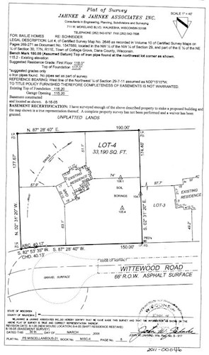
Certified Survey Maps (CSM): Required by statute $2 first page and $1 per additional page
Survey Maps Larger than 11x17: $5 per page
Survey Maps 11x17 or Smaller: $1 per page
Monument Reports, Tie Sheets, Condition Certificates, and Section Summaries: $1 total – regardless of pages
Activities include:
Current Projects:
Digital Submission of Surveys - You can submit your surveys digitally (not plats, CSM's or condos) to the County Surveyor for filing by clicking on THIS LINK. You can upload your surveys (in TIF format) to the Sharefile by dragging and dropping.
Digital Submission of Tie Sheets - You can submit your tie sheets digitally to the County Surveyor for filing by clicking on THIS LINK. You can upload your tie sheets (in TIF format) to the Sharefile by dragging and dropping.
Program Development - The County Surveyor has developed a workplan focused on improving the quality and availability of survey information in Dane County. The workplan identifies needed automation projects and additional community services. The plan will be reviewed by local survey professionals and be administered by the County Surveyor on an annual basis.
Remonumentation - The County Surveyor is coordinating a long term countywide USPLSS Re-monumentation effort. These monuments make up the skeletal structure of our land ownership system. This project will benefit residents in many ways, some of which are cost savings on property surveys, more accurate mapping in the Dane County parcel data and Farm Services Agency data, and provide a much more accurate base for analyzing title issues. An example of the letter sent to each community before work begins is located HERE. You can see the project status map HERE.
Survey Network Improvements - As a part of the Fly Dane 2000 project, the Dane County survey network was inventoried and additional geodetic and photo control established. A final report, including monument records and published coordinate values, is nearing completion.
Surveyor's Office - Dane County has purchased Surveyor's Office to manage and publish survey control information. The database is currently under development, and will include all Dane County geodetic, PLSS and photo control information. The software supports GIS queries and displays, and will be enhanced in the future to include image files such as tie sheets and corner reports.
GIS/Mapping - The County Surveyor oversees the development and maintenance of the county's GIS databases as relates to survey information, as well as providing quality control and professional support services to support GIS parcel mapping. The GIS survey control layers form the spatial reference framework for a variety of Dane County GIS layers. GIS parcel maps have been completed countywide and are now in an ongoing maintenance mode. An annual archive of GIS parcel maps was begun in 2000.
Plat Imaging - Dane County Recently began a countywide imaging project. As a part of this project, survey plats and other historical documents maintained by the County Surveyor will be scanned and accessed through image viewing software.
Links:
This application provides a central point of access to over 28,000 control points and over 200,000 Public Land Survey System (PLSS) corner records in Wisconsin. To submit data and/or view the data model, CLICK HERE.
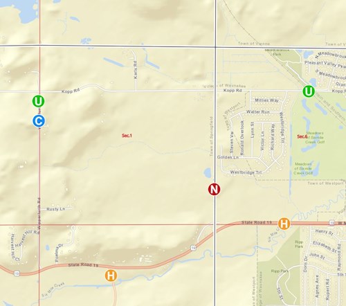
Data layers include:
NGS Control (red symbol):
The mission of the NGS is to “define and manage a national coordinate system” known as the National Spatial Reference System (NSRS). The NSRS is a consistent coordinate system that defines a number of parameters for each geodetic control monument in the United States. Direct linkage is provided to its online datasheet from the NSRS database.
USGS Control (green symbol):
USGS 3rd Order Vertical Control is legacy elevation data of varying quality. The horizontal positions of these points were derived from 1:24,000-scale map sources as well as extracted from a USGS database (WIVERT). Horizontal accuracy varies according to source of derived position. Each of these points has an elevation as well as a “to reach” description. The USGS control is not actively maintained by anyone in Wisconsin. Our office has undertaken voluntary custodianship of the information for purposes of historical reference. We also maintain station condition reports as an aid in monument recovery.
WI-HMP Control (orange symbol):
To improve the density of vertical bench marks listed in the NSRS with accurate orthometric heights (elevations), the WIDOT, in cooperation with the NGS, has been working on the WI-HMP since 1998 to improve elevation data throughout Wisconsin.
CORS Control (black triangle):
The WIDOT Geodetic Survey Unit developed a Wisconsin Continuously Operating Reference System (WISCORS) network. These permanent GPS sites, which provide real-time corrections to mobile users, can be viewed and accessed. The NGS coordinates a CORS network of Continuously Operating Reference Systems that provide GPS carrier and code range measurements in support of 3-dimensional positioning activities throughout the U.S. County Control (blue symbol): Various counties have added their control point information to ControlFinder, providing a common entry point for geodetic control in Wisconsin. In all cases, the county maintains complete authority, stewardship, and responsibility for their data.
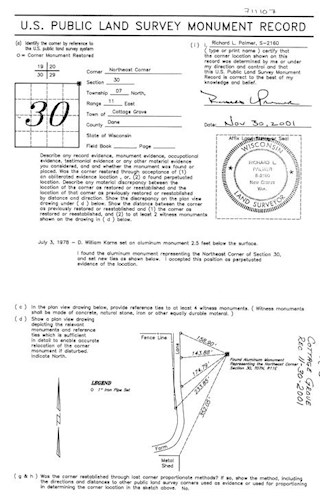
PLSS Corners (red squares):
Progress towards updated PLSS corner monuments and coordinates varies widely across the state, with some counties having completed remonumentation, while others are at various stages of completion. The Wisconsin County Surveyor’s Association endorsed this as a vehicle representing statewide county collaborations for displaying and providing access of their progress towards the completion and maintenance of the PLSS in the state. Many corners have direct linkage to their online tiesheet as maintained by the county.
For your convenience we also provide export functions such as KML, Shapefile, GeoJSON and CSV file formats.
