Acknowledge - Act
ACKNOWLEDGE
Does your property have discriminatory restrictive language, covenants, or restrictions on your deed? Learn by viewing the map above or clicking this link.
Check out this exhibit: UNJUST DEEDS: A History of Racial Covenants in Dane County and Beyond in Dane County and Madison. The exhibit consists of 14 pull-up banners and will be displayed in 12+ libraries and the Bookmobile. www.danecountyhistory.org.
Dane County Planning and Development and several partners are heading out into the community to help relevant property owners to formally file the “Discharge and Release of Discriminatory Restriction Affecting Real Property.”
Property assistants and notaries will be present to help and validate your documents which will then be taken to the Register of Deeds for you. Document recording fees are waived thanks to a grant from the Wisconsin Realtors Association Foundation.
ACT
Property owners can:
- Book Time to Denounce Discrimination in Your Deed with staff at 210 Martin Luther King Jr. Blvd, Madison Rm 116.
- Attend a “fill and file” event listed in right-hand side bar below.
If you are interested in hosting a Fill and File event for multiple property owners, please contact Dane County Planning and Development at plandev@danecounty.gov or call 608-266-4266
BACKGROUND
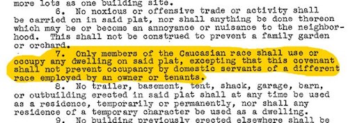
Racial covenants were a wide spread tool for preventing property sales to people of particular descent up through the early and mid-1900’s. In 1917, the US Supreme Court invalidated racial zoning, causing the use of restrictive covenants to proliferate as an exclusionary tool. While racially restrictive covenants include language targeting many racial, religious, and ethnic groups, they especially targeted Black people during the Great Migration (1910-40), when millions moved North and West to seek new opportunities.
In 1948, the Supreme Court made covenants unenforceable by public law in Shelley v Kraemer. Twenty years later, the Fair Housing policy in the Civil Rights Act of 1968 prohibited discrimination concerning housing sale, rental, and financing based on race, religion, national origin, sex, (and as amended) handicap, and family status. However, despite no longer being enforceable by law, covenants are still in land deeds and could be implemented via private action.
Mapping Prejudice in Seattle Washington is one of the first efforts to chronical these documents. The University of Minnesota’s Mapping Prejudice Project researched, validated, and seeks to discharge these restrictive records for Hennepin County, Minnesota. Similar work is also underway in Milwaukee, and several other regions of the nation. Inspired by these efforts, Dane County Planning and Development (P&D), Office of Equity and Inclusion, and the Dane County Boys and Girls Club (BGC) conducted a pilot study to identify and analyze records from 1937-1969 in June 2022 and subsequently expanded to 1900-1937.
On March 22, 2024, Governor Evers signed the 2023 Wisconsin ACT 210 [59.43 (9) (d) and 710.25] declaring discriminatory restrictions in instruments that affect real property void and unenforceable and allowing an owner of real property to discharge and release such a discriminatory restriction.